If you are new to using GIS software or a casual user you may be surprised to learn that standard formats such as shape files do not contain sufficient information for successfully transferring data between systems.
For instance if you have been sent some shape files together with how they should appear in your system, and you are presented with something different when they are loaded, there is a simple explanation.
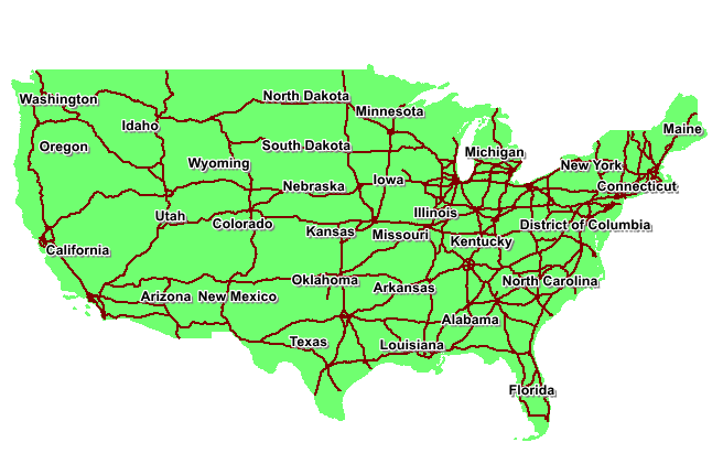
Here is a screen shot of how two layers should display in your system.
For instance if you have been sent some shape files together with how they should appear in your system, and you are presented with something different when they are loaded, there is a simple explanation.
Here is a screen shot of how two layers should display in your system.
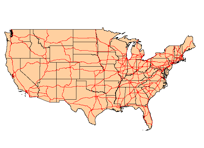
And here is how it may look if loaded in just a default shape format.
The problem is that shape files layers load into most GIS software packages with a random colour. If you load the same layer a number of times it will load each time with a different colour. Also shape files do not contain any information about how the layer should display or whether labels should be in a specific font, colour etc.
The shape file is a format developed by Esri for their original ArcGIS software system. This format is now a standard within the GIS community. However, whilst the shape file contains valuable information about how the layer should display together with any associated attribute data, other information such as layer styles and labelling information are not included.
GIS software packages have methods of dealing with saving and successfully restoring layer styles and labelling information by using project files. Then when the layers are reloaded, by using this project file method, all the appropriate information is automatically restored. This may also include layer order and thematic layer information.
One of the main problems with the transfer of all the relevant information between different GIS software packages is that the project file format is not compatible between systems. For example, MapInfo Pro has a wor. format project system to save layer information together with other important data. All the other major systems such as ArcGIS Pro and QGIS also have similar project functionality
There are a number of ways to address these compatibility issues. Firstly, the layer information can be saved in a separate layer file which has a .lyr format. Then each layer can have its own layer format file so as to ensure the layers display correctly. There are now a number of such layer formats available. Unfortunately, not all of them are compatible but it should be possible to find one which will work between the GIS software packages that you use.
 RSS Feed