jps services
  • Home Page
  • GIS Training Courses
    • QGIS Training Courses
    • ArcGIS Training Courses
    • MapInfo Pro Training Courses >
      • MapBasic Training Course
  • About
  • Blog

GIS: A Compelling Software Solution

26/10/2014

0 Comments

 
There is a saying that 'a picture tells a thousand words' and that is certainly the case when referring to the mapping of business data. The combination of tabular data and maps enables trends to be more easily detected and analysed. Maps can be a powerful means of communicating results to colleagues.
More and more businesses are storing masses of data in corporate databases. As this data has increased dramatically so has the need to speed up the process of analysis. The use of spreadsheets and related graphs have improved the ability to make sense of data. Since the advent of the personal computer the spreadsheet has become an integral part of analysis of business data. Combining the use of desktop software such as spreadsheets with mapping technology has dramatically changed data analysis and presentation.
We can easily demonstrate the power of mapping to visualize business data with a simple example. Below is part of a spreadsheet of income distribution within the London boroughs. 
Income Distribution in London Boroughs
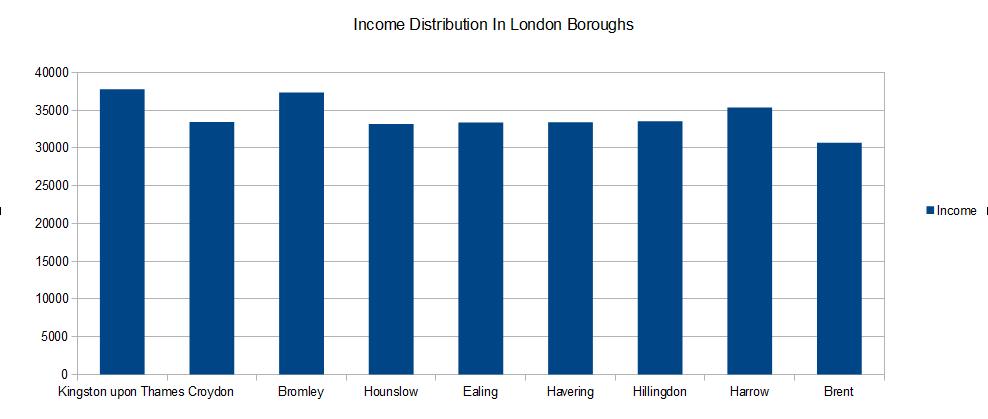
Income Distribution Spreadsheet Example

Read More
0 Comments

GIS Training Course Options

4/10/2014

0 Comments

 
If you have to learn how to use a GIS desktop solution such as QGIS, MapInfo or ArcMap you may be expected to attend a training course. Courses can be introductory ie they last for a couple of days or intermediate or advanced. The advanced courses can last for up to two weeks, depending on your individual companies' requirements, and may involve acquiring programming skills.

At the introductory level you will learn all about the basic functionality available within your chosen GIS package. All the popular desktop systems have many features in common so learning how to use one will stand you in good stead if you also need to use alternative solutions. The most popular desktop GIS include ArcMap, MapInfo and QGIS. Both ArcMap and MapInfo are what is known as proprietary systems. ArcMap and MapInfo are both well documented and supported by their respective suppliers and are purchased both directly and through agents. QGIS is open source software and as such is available for download without any cost implications. However, whilst the software is free you are still expected to abide by the terms and conditions of open source licencing.

Many organisations are now using a combination of open source and proprietary software to meet their specific requirements. Both local and national governments are now expecting departments to evaluate both proprietary and open source software to ensure that the most cost effective solution is provided.

Whatever GIS solution is decided upon, in order to achieve the most benefit, it is essential to set aside sufficient budget to train staff properly so that they can make optimum use of the chosen system.


0 Comments

    Author

    Joe Short BSc has been involved with various mapping solutions for over twenty years.  If you are considering implementing a GIS  or have ArcGIS Pro, MapInfo Pro or QGIS training requirements, jps services would be happy to be of assistance to your organisation. 

    Archives

    May 2025
    March 2025
    March 2024
    October 2023
    September 2023
    August 2023
    March 2023
    April 2020
    March 2020
    October 2019
    September 2019
    August 2019
    July 2019
    March 2019
    November 2018
    October 2018
    August 2018
    July 2018
    November 2017
    October 2017
    September 2017
    July 2017
    February 2017
    January 2017
    December 2016
    November 2016
    October 2016
    May 2016
    February 2016
    September 2015
    August 2015
    April 2015
    February 2015
    November 2014
    October 2014
    July 2014
    June 2014
    May 2014
    March 2014
    February 2014
    December 2013
    November 2013
    October 2013
    September 2013
    August 2013
    June 2013
    May 2013
    April 2013
    February 2013
    December 2012
    October 2012
    September 2012
    August 2012
    July 2012

    Categories

    All
    Arc Gis
    Arcview
    Autodesk
    Cad
    Gis Training
    Local Government
    Mapbasic
    Mapinfo
    Quantum Gis
    Relational Databases
    Saga Gis

    RSS Feed