There are many different formats available for use within the main GIS desktop software packages such as QGIS, MapInfo and ArcGIS. Some formats have been around for a long time such as shape files (.shp) from ESRI and tab files (.tab) from MapInfo. The ability to be able to work with these common formats is essential for many software GIS users as these system formats used by ArcGIS and MapInfo have significant user bases in both commercial and public organisations. So the ability to be able send and receive data from these two GIS software packages is seen as a 'must have' for any competing solution such as open source systems like QGIS.
Some data however does not fall into the categories mentioned above. For instance, you may have data from a database or a spreadsheet which you would like to incorporate into your map. With database formats you will often come across SQL based systems from Oracle or Microsoft. These databases, unlike data from spreadsheets, contain relational based tables that are linked through common fields. This linking facility gives them their relational database capability. Many GIS systems can now link directly to this type of database. Some relational databases also support geometry fields. Some powerful relational databases such as PostgreSQL link directly to GIS systems such as QGIS and support point, line and polygon geometry within the database fields. Both PostgresSQL and QGIS are open source software packages.
If you have data from a spreadsheet with co-ordinate information you can normally create points within your map to represent the x and y or latitude and longitude data if you can import your data in a CSV (comma separated) format. For this reason it is normally saved by the spreadsheet software as a comma separated file prior to loading in the GIS. Alternatively, if you do not possess the appropriate co-ordinate data you can still sometimes link your spreadsheet data to other data which does have this information via a join facility within the GIS software.
Besides relational databases and flat file formats, such as spread sheets, you may also come across what is known as No SQL database formats. These systems, such as MongoDB, do not have a relational database structure and could be compared to the flat file format of a spreadsheet. However, this file format is more sophisticated than that offered by a flat file format. No SQL databases have some advantages over relational databases. For instance they do not need a schema to be set up prior to creating the database. They are more flexible in that additional fields can be added to some elements of the database without impacting on other parts of the structure. This type of database uses a java based format called JSON. This stands for java script object notation. If you have some data in this format which you would like to use within a GIS such as QGIS you can do this by using the GEOJSON vector layer option. Your file in that instance should contain geometry data which can be line or polygon in addition to the point geometry available within a text or spreadsheet file. If your file does not have geometry you could still import the JSON data as a comma separated text file.
Below is part of a JSON file which contains polygon geometry.
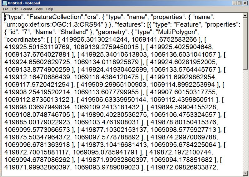
This file was stored within Notebook and is in a readable format. This file format makes use of curly brackets and square brackets to inform the system of what kind of data is being stored. Each field is defined by "Type": and is separated by commas. The system supports various formats such as text, numbers and booleans. Arrays can be defined with the use of square brackets.
Here is the map to which this data is related.
Here is the map to which this data is related.
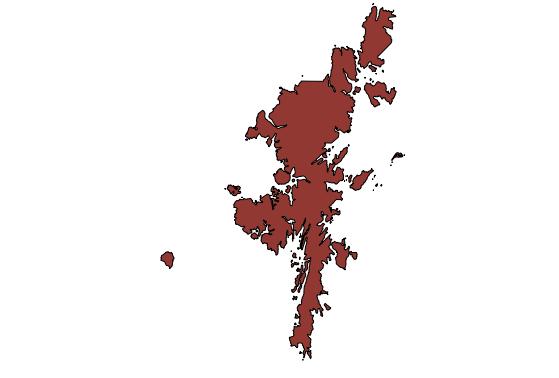
Data within MongDB is interrogated with a dot format such as db.test.find() rather than the SQL statements used in a relation based database. Geometry data can be stored for points, lines and polygons. As you can see the polygon data is a series of data points which can be loaded into a GIS which supports GEOJSON format. However, the capability for sophisticated analyse of geometry is still mainly available within relational database systems at the time of writing.
Once your data is displayed within the GIS you can then save it to another format such as shape or tab so it can used in other GIS software solutions that perhaps do not support GEOJSON or JSON based systems.
If you would like to further explore how GIS could help your organisation jps services offers one and two day training courses in QGIS, ArcGIS and MapInfo.
 RSS Feed