Legacy Layout v Layout Designer code
MapInfo Pro provides some information in MapBasic Help concerning legacy code for creating layout windows. However, some features within the legacy layout, available in earlier versions of MapInfo, are no longer supported. For instance, earlier versions of MapInfo had a graph function. Graphs are no longer supported so any code to include graphs in a layout is now redundant and needs to be removed. If the code is left in, at best you will end up with a blank space in the layout, or MapInfo may try to fill the space with a map window frame.
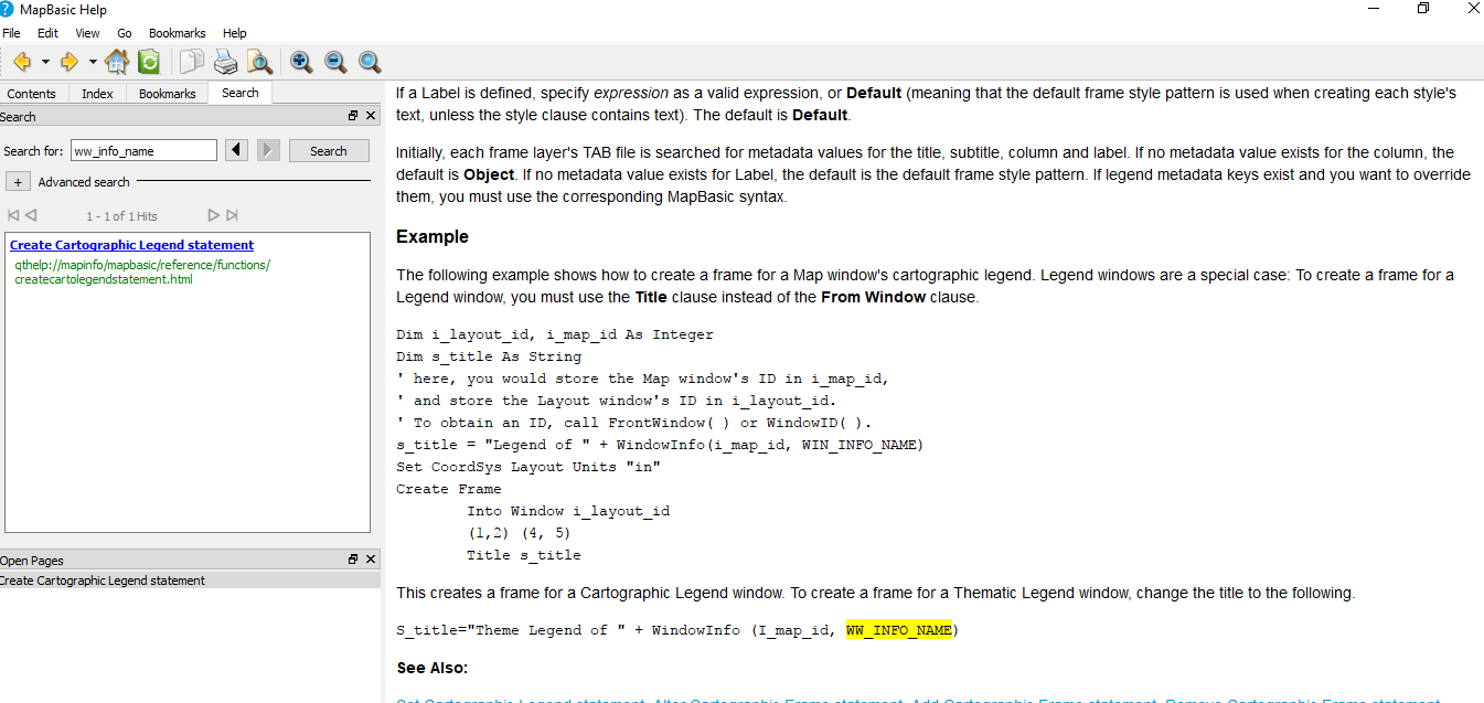
Another issue concerning coding is thematic and cartographic legend layer support for legacy code. If you look up cartographic legend in MapBasic Help you will find code which was developed for the legacy layout format. Below is a section from the Create Cartographic Legend section.
Another issue concerning coding is thematic and cartographic legend layer support for legacy code. If you look up cartographic legend in MapBasic Help you will find code which was developed for the legacy layout format. Below is a section from the Create Cartographic Legend section.
The first section of this code which should create a Cartographic Legend window creates errors when run in MapInfo Pro. The second section of code should create a frame for a Thematic Legend window. However the recommendation to create a frame for a Thematic Legend window, by changing the title to the following does not work as it contains errors:-
S_title="Theme Legend of " + WindowInfo (I_map_id, WW_INFO_NAME)
By using a note statement you can ascertain the legend name using the first section of the code snippet as shown in the screen below.
S_title="Theme Legend of " + WindowInfo (I_map_id, WW_INFO_NAME)
By using a note statement you can ascertain the legend name using the first section of the code snippet as shown in the screen below.
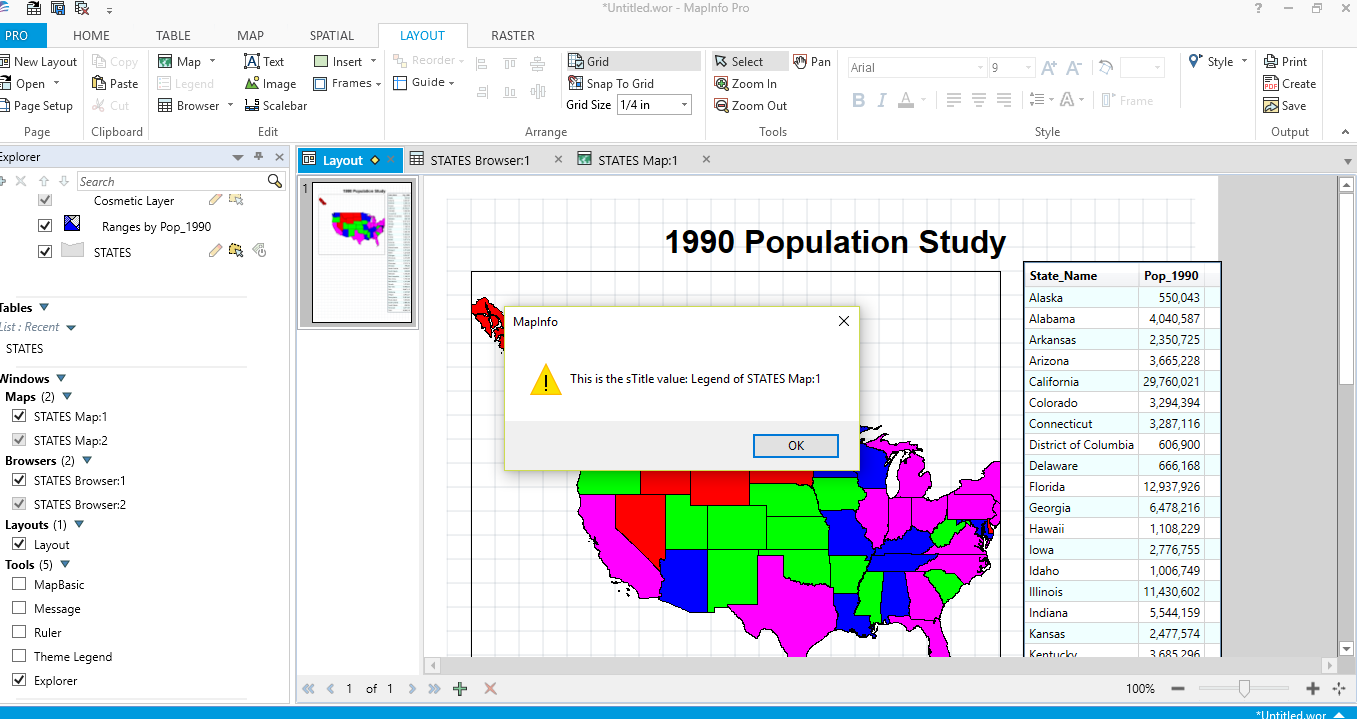
After this point an error screen appeared and the legend is not created.
The code snippet for creating a thematic legend doesn’t work as anticipated either.
If we take another look at this line of code:-
S_title="Theme Legend of " + WindowInfo (I_map_id, WW_INFO_NAME)
If we take another look at this line of code:-
S_title="Theme Legend of " + WindowInfo (I_map_id, WW_INFO_NAME)
The first thing to note is S_title which should actually be s_title. The word processor which created this section of the help file has automatically changed this variable from s_title to S_title as it was at the beginning of sentence. The same problem occurs with I_map_id. This should be i_map_id if it is to be consistent with the earlier code sample.
The next thing to note is that WW_INFO_NAME must be a typing error. This should read WIN_INFO_NAME.
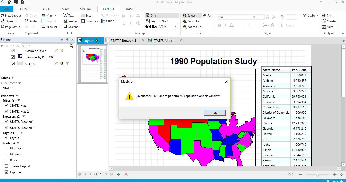
Even so when these corrections are made the code still doesn’t get beyond a note statement. As shown in the next image.
The next thing to note is that WW_INFO_NAME must be a typing error. This should read WIN_INFO_NAME.
Even so when these corrections are made the code still doesn’t get beyond a note statement. As shown in the next image.
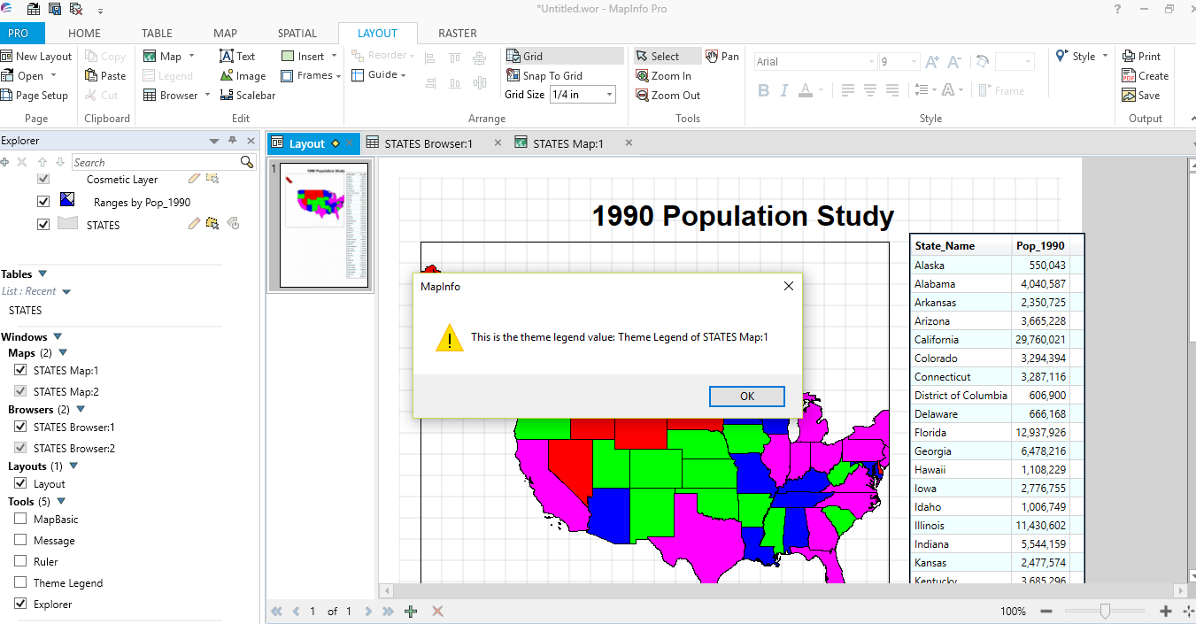
This time after the note statement has been dismissed, no error occurs and the layout completes but without creating a legend element.
So it would appear that even using the legacy Layout statement with various legacy code provided in MapBasic help, the latest versions of MapInfo Pro do not appear to be able to create cartographic or thematic legends in the layout window with this legacy code.
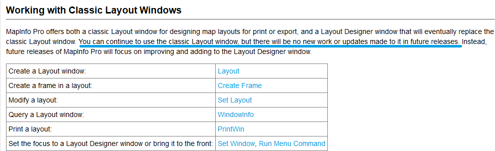
The Help section spells out the demise of the classic layout window and any related code as the following graphic from Help shows. The relevant statement has been highlighted.
The Help section spells out the demise of the classic layout window and any related code as the following graphic from Help shows. The relevant statement has been highlighted.
So looking at what is and is not appearing in the layout we should note the following;-
- Maps can be brought into a layout, the classic layout Title clause now appears to be optional.
- Browsers, text and eclipse statements all work without an issue with legacy code.
Layout Designer window
At this stage it is useful to note the main difference between the legacy and designer layouts. The new Layout Designer has some powerful features. For instance a major benefit is that you can adjust elements within a layout map frame without having to return to the map window. For all the benefits of the new layout designer please check out the Help section in MapInfo Pro. The MapBasic Help provides information on how to use the new Layout Designer window.
Here is a screen shot from MapBasic Help which also includes some useful code:-
Here is a screen shot from MapBasic Help which also includes some useful code:-
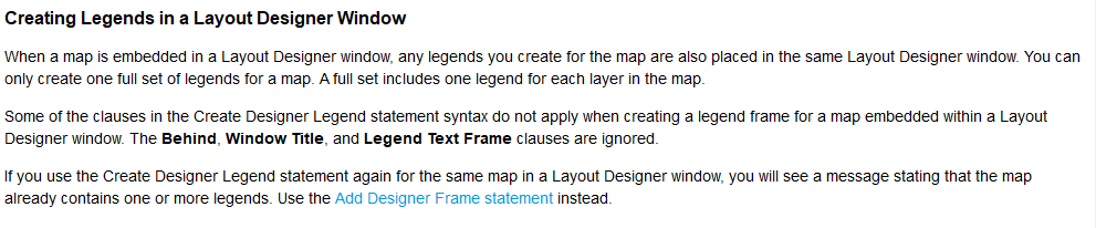
This section is useful because it also includes some code which shows how to create a cartographic legend window.
However, this code produces a legend window in the map section rather than in a layout window. We need to modify this code so that it can be used directly in the layout window.
However, this code produces a legend window in the map section rather than in a layout window. We need to modify this code so that it can be used directly in the layout window.
Creating MapBasic code for a Layout Designer window
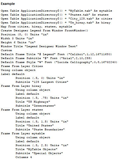
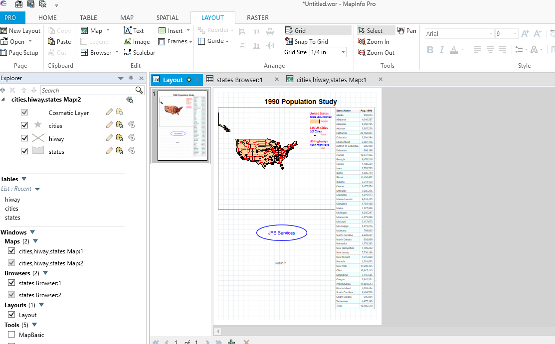
Here is some sample code to create a map and browser window which are then incorporated into a layout designer window. The layout also includes cartographic legends for each of the map layers.
Include "C:\Program Files (x86)\MapInfo\MapBasic\mapbasic.def"
Declare Sub Main
Sub Main
Dim nMapWinid As Integer
Dim nLayoutWinid As Integer
Dim nBrowseWinid As Integer
Dim sString As String
' Open three tables
Open Table "C:\MapInfo Trial Data\USA\States.tab" As states
Open Table "C:\MapInfo Trial Data\USA\City_125.tab" As cities
Open Table "C:\MapInfo Trial Data\USA\Us_hiway.tab" As hiway
' Create map layers for these tables
Map From cities, hiway, states
Set Map Zoom 6370
' Save the current map window's ID
nMapWinid = Frontwindow()
' Create a browser window for columns State_Name and Pop_1990
Browse State_Name, Pop_1990 from STATES
' Save the current browser window's ID
nBrowseWinid = FrontWindow()
' Create a new layout designer window
Layout Designer Width 4 Height 6
' Save the layout window's ID
nLayoutWinid = FrontWindow()
Set CoordSys Layout Units "in"
' Add the map window to the layout window.
Create Frame Into Window nLayoutWinid
(0.235,1) (6,6)
From Window nMapWinid
' The following code is modified from the help section
' This code creates the cartographic legend for the three map layers
Create Designer Legend
Position (0,0) Units "in"
Width 0 Units "in" Height 0 Units "in"
Custom
Default Frame Title "# Legend" Font ("Calibri",1,12,16711680)
Default Frame Subtitle "#" Font ("Arial",2,10,255)
Default Frame Style "%" Font ("Lucida Calligraphy",0,8,16732240)
Default Frame Line Width 36 Units "pt"
Default Frame Region Width 32 Units "pt"
Default Frame Region Height 14 Units "pt"
Default Frame Auto Font Size ON
' Note that we here we can use the map layer names
Frame From Layer states
Using column object
label default
Position (4.7,1.14) Units "in"
Title "United States"
Subtitle "State Boundaries"
Frame From Layer cities
Using column object
label default
Position (4.7,1.85) Units "in"
Title "125 US Cities"
Subtitle "US Cities"
Frame From Layer hiway
Using column object
label default
Position (4.7,2.5) Units "in"
Title "US Highways"
Subtitle "Main Highways"
' Add the browser window to the layout window
Create Frame Into Window nLayoutWinid
(5.985, 0.985) (7.9, 10.9)
From Window nBrowseWinid
' Add a title to the layout
Create Text Into Window nLayoutWinid
"1990 Population Study"
' (2.5 Across.5 Down) (8 Across .9 Down)
(2.5,.5) (8,.9)
Font MakeFont ("Arial", 1, 24, BLACK, WHITE)
' Add company name and today's date to the layout.
Create Ellipse Into Window nLayoutWinid
(2.1, 6.75) (4.6, 7.55)
Pen (3,2, BLUE)
Create Text Into Window nLayoutWinid
"JPS Services"
(2.1, 7.03) (4.6, 7.3)
Font MakeFont("Arial", 0, 16, BLUE, WHITE)
Justify Center
sString = Str$(CurDate())
Create Text Into Window nLayoutWinid
sString
(3,8.6) (4, 8.9)
Font MakeFont("Arial", 0, 8, BLACK, WHITE)
Justify Left
End Sub
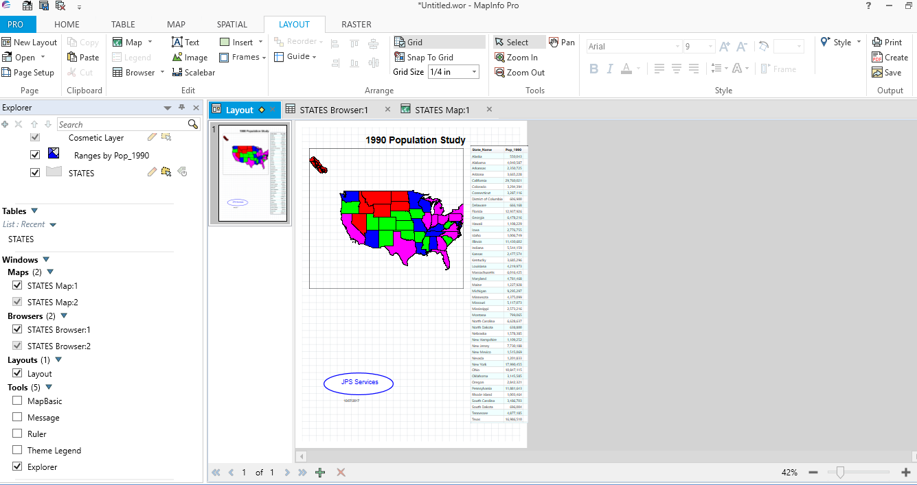
If you run this code you will produce the following layout page.
Here is a close up of the cartographic legend:-
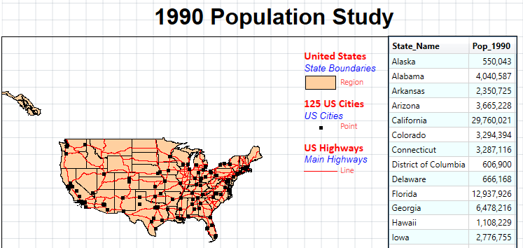
Creating a cartographic legend is not too difficult as we can easily ascertain the layer names. The problem arises when you also need to include a thematic map with a thematic legend in your layout.
The following code should be sufficient to create a thematic legend:-
The following code should be sufficient to create a thematic legend:-
Frame From Layer (thematic layer name)
Position (3.7,1.16) Units "in"
Title "US by 1990 Population"
Priority 10
Position (3.7,1.16) Units "in"
Title "US by 1990 Population"
Priority 10
However, unlike the map frames, as the thematic layer name is created automatically we need to find some way of ascertaining it.
When run from the map window the following code reveals the names and types of all of the open layers.
When run from the map window the following code reveals the names and types of all of the open layers.
include "mapbasic.def"
Declare sub main
Sub Main
dim i,j as integer
j = frontwindow()
for i = 1 to mapperinfo(j,MAPPER_INFO_LAYERS)
print "No: " + i +
", Name: " + layerinfo (j,i,LAYER_INFO_NAME) +
", Type: " + layerinfo (j,i,LAYER_INFO_TYPE)
next
end sub
Declare sub main
Sub Main
dim i,j as integer
j = frontwindow()
for i = 1 to mapperinfo(j,MAPPER_INFO_LAYERS)
print "No: " + i +
", Name: " + layerinfo (j,i,LAYER_INFO_NAME) +
", Type: " + layerinfo (j,i,LAYER_INFO_TYPE)
next
end sub
The output in the message window is shown in the next graphic:
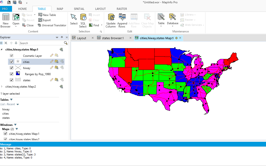
The thematic layer is called Ranges by Pop_1990 (as shown in the Explorer section). In the message section the thematic layer is shown as states(1). Type 3 confirms that this is the thematic layer. So is this layer called Ranges by Pop_1990 or states(1)? If you put either name into the code shown below you will get an error.
Frame From Layer (thematic layer name)
Position (3.7,1.16) Units "in"
Title "US by 1990 Population"
Priority 10
Position (3.7,1.16) Units "in"
Title "US by 1990 Population"
Priority 10
However if we assign a variable to hold the thematic name as in the following code we can create a thematic legend:-
j = nMapWinid
for i = 1 to mapperinfo(j,MAPPER_INFO_LAYERS)
if layerinfo(j,i,LAYER_INFO_TYPE) = 3 Then
sThematicLayer = layerinfo(j,i,LAYER_INFO_NAME)
End If
next
for i = 1 to mapperinfo(j,MAPPER_INFO_LAYERS)
if layerinfo(j,i,LAYER_INFO_TYPE) = 3 Then
sThematicLayer = layerinfo(j,i,LAYER_INFO_NAME)
End If
next
This code snippet uses mapperinfo() and iterates through the layers looking to see if any are of type 3, thematic layer type. If there is a thematic layer then sThematicLayer is assigned the thematic layer name. Please note the above code only works when the appropriate variables have been declared within the program.
The following code creates a map, browser and thematic layer. Then a layout is created with a thematic legend included.
The following code creates a map, browser and thematic layer. Then a layout is created with a thematic legend included.
Include "C:\Program Files (x86)\MapInfo\MapBasic\mapbasic.def"
Declare Sub Main
Sub Main
Dim nMapWinid , i, j As Integer
Dim nLayoutWinid As Integer
Dim nBrowseWinid As Integer
Dim sString, sThematicLayer As String
' Open three tables
Open Table "C:\MapInfo Trial Data\USA\States.tab" As states
Open Table "C:\MapInfo Trial Data\USA\City_125.tab" As cities
Open Table "C:\MapInfo Trial Data\USA\Us_hiway.tab" As hiway
' Create map layers for these tables
Map From cities, hiway, states
Set Map Zoom 6370
' Create a thematic map of the States layer
Shade states With Pop_1990
Ranges 400000: 1500000,
1500000: 3500000,
3500000: 5500000,
5500000: 29800000
nMapWinid = Frontwindow()
' This code obtains the thematic layer name
j = nMapWinid
for i = 1 to mapperinfo(j,MAPPER_INFO_LAYERS)
if layerinfo(j,i,LAYER_INFO_TYPE) = 3 Then
sThematicLayer = layerinfo(j,i,LAYER_INFO_NAME)
End If
next
' Create a browser window for columns State_Name and Pop_1990
Browse State_Name, Pop_1990 from STATES
nBrowseWinid = FrontWindow()
' Create a new layout window
Layout Designer Width 4 Height 6
nLayoutWinid = FrontWindow()
Set CoordSys Layout Units "in"
' Add the map window to the layout window.
Create Frame Into Window nLayoutWinid
(0.235,1) (6,6)
From Window nMapWinid
' The following code is modified from MapBasic Help section
Create Designer Legend
Position (0,0) Units "in"
Width 0 Units "in" Height 0 Units "in"
Custom
Default Frame Title "# Legend" Font ("Calibri",1,12,16711680)
Default Frame Subtitle "#" Font ("Arial",2,10,255)
Default Frame Style "%" Font ("Lucida Calligraphy",0,8,16732240)
Default Frame Line Width 36 Units "pt"
Default Frame Region Width 32 Units "pt"
Default Frame Region Height 14 Units "pt"
Default Frame Auto Font Size ON
' Note that here we need to use
' the thematic layer name from
' code provided earlier in the program
Frame From Layer sThematicLayer
Position (3.7,1.16) Units "in"
Title "US by 1990 Population"
Priority 10
' Add the browser window to the layout window
Create Frame Into Window nLayoutWinid
(5.985, 0.985) (7.9, 10.9)
From Window nBrowseWinid
' Add a title to the layout
Create Text Into Window nLayoutWinid
"1990 Population Study"
' (2.5 Across .5 Down) (8 Across .9 Down
(2.5, .5) (8, .9)
Font MakeFont ("Arial", 1, 24, BLACK, WHITE)
' Add company name and today's date to the layout.
Create Ellipse Into Window nLayoutWinid
(2.1, 6.75) (4.6, 7.55)
Pen (3,2, BLUE)
Create Text Into Window nLayoutWinid
"JPS Services"
(2.1, 7.03) (4.6, 7.3)
Font MakeFont("Arial", 0, 16, BLUE, WHITE)
Justify Center
sString = Str$(CurDate())
Create Text Into Window nLayoutWinid
sString
(3,8.6) (4, 8.9)
Font MakeFont("Arial", 0, 8, BLACK, WHITE)
Justify Left
End Sub
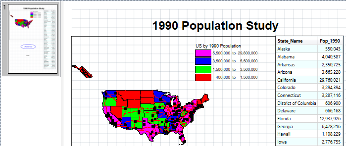
This code creates the following layout page.
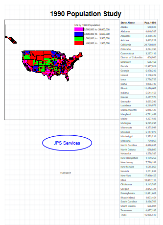
The following graphic shows a close up of the thematic legend.
In conclusion using MapBasic to create layout pages or to modify existing legacy code requires some understanding of the recent significant developments in the capability of MapInfo Pro.
When looking at the Help section in MapBasic be aware that some of the sections are referring to legacy code although this is not always explicitly stated.
Moving forward any layout code should be developed using the Layout Designer rather the classic Layout code to ensure that all elements of your layout are displayed correctly.
 RSS Feed