If you're new to GIS (Geographic Information Systems), you might wonder how to perform specific tasks efficiently. QGIS, an open-source GIS software, provides a powerful scripting interface that allows you to automate processes. In this blog, we'll explore a practical example: calculating the total area of features in a vector layer using a custom script. Don't worry; we'll break it down step by step.
Why Calculate Total Area?
Calculating the total area of features in a vector layer can be essential in various GIS projects. For instance, you might want to determine the total area of land parcels, water bodies, or administrative regions in a map. This information is valuable for urban planning, environmental analysis, and many other applications.
The QGIS Script
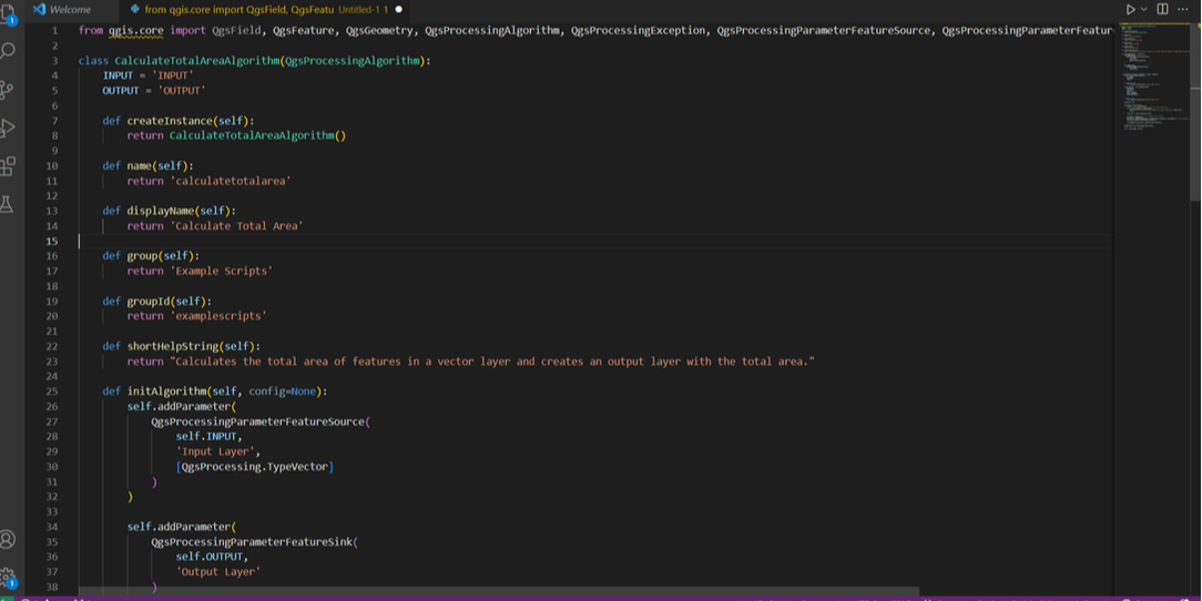
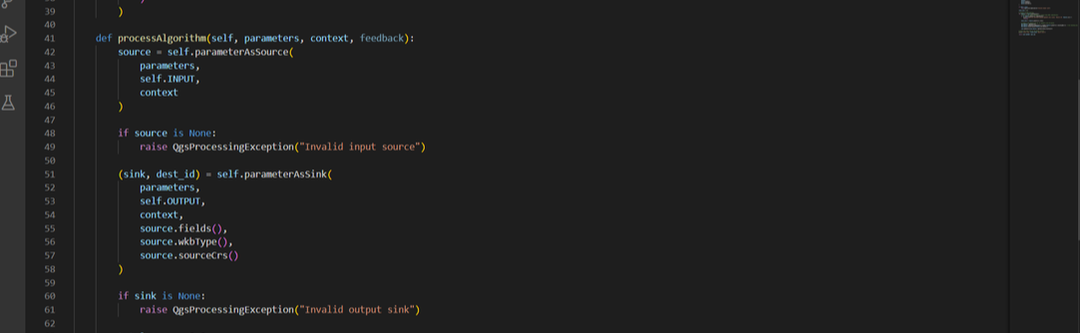
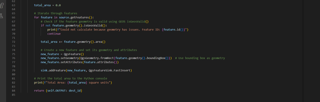
Here's the Python script that accomplishes this task:
Why Calculate Total Area?
Calculating the total area of features in a vector layer can be essential in various GIS projects. For instance, you might want to determine the total area of land parcels, water bodies, or administrative regions in a map. This information is valuable for urban planning, environmental analysis, and many other applications.
The QGIS Script
Here's the Python script that accomplishes this task:
How the Script Works
Let's break down the script into simpler terms:
1. Imports and Class Definition: The script starts by importing necessary modules from QGIS. Then, it defines a custom algorithm class `CalculateTotalAreaAlgorithm` that inherits from `QgsProcessingAlgorithm`. This class contains several methods that control the algorithm's behavior.
2. Algorithm Configuration: The `initAlgorithm` method sets up the algorithm's parameters. In this case, it defines the input and output layers.
3. Processing: The core logic happens in the `processAlgorithm` method. Here's a simplified explanation of what it does:
- It retrieves the input vector layer.
- It checks if the input source is valid.
- It prepares an output layer.
- It iterates through the features in the input layer.
- For each feature, it checks if the geometry is valid.
- If the geometry is valid, it calculates the area and creates a new feature.
- The new features are added to the output layer.
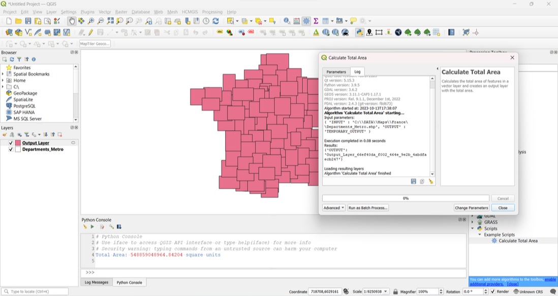
4. Result: The script prints the total area to the Python console and returns the output layer.
Running the Script
To run this script in QGIS, you'll need to:
1. Open QGIS.
2. Go to the 'Processing' menu.
3. Open the 'Toolbox.'
4. Save your script as 'Calculate Total Area'
5. Under 'Scripts,' you should find 'Example Scripts,' and within that, 'Calculate Total Area.'
Let's break down the script into simpler terms:
1. Imports and Class Definition: The script starts by importing necessary modules from QGIS. Then, it defines a custom algorithm class `CalculateTotalAreaAlgorithm` that inherits from `QgsProcessingAlgorithm`. This class contains several methods that control the algorithm's behavior.
2. Algorithm Configuration: The `initAlgorithm` method sets up the algorithm's parameters. In this case, it defines the input and output layers.
3. Processing: The core logic happens in the `processAlgorithm` method. Here's a simplified explanation of what it does:
- It retrieves the input vector layer.
- It checks if the input source is valid.
- It prepares an output layer.
- It iterates through the features in the input layer.
- For each feature, it checks if the geometry is valid.
- If the geometry is valid, it calculates the area and creates a new feature.
- The new features are added to the output layer.
4. Result: The script prints the total area to the Python console and returns the output layer.
Running the Script
To run this script in QGIS, you'll need to:
1. Open QGIS.
2. Go to the 'Processing' menu.
3. Open the 'Toolbox.'
4. Save your script as 'Calculate Total Area'
5. Under 'Scripts,' you should find 'Example Scripts,' and within that, 'Calculate Total Area.'
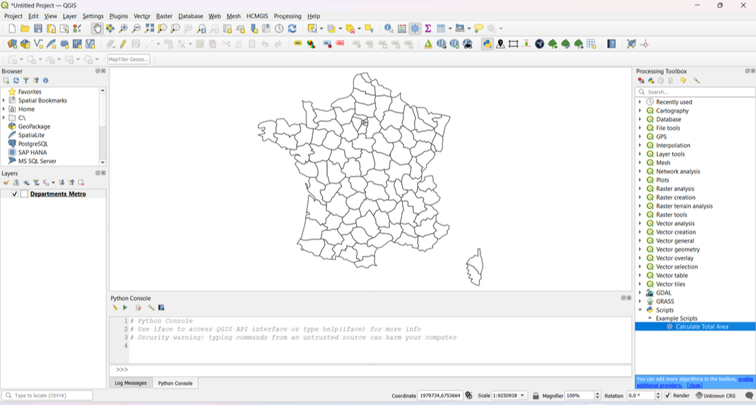
6. Set your input vector layer.
7. Choose an output location.
8. Click 'Run.'
7. Choose an output location.
8. Click 'Run.'
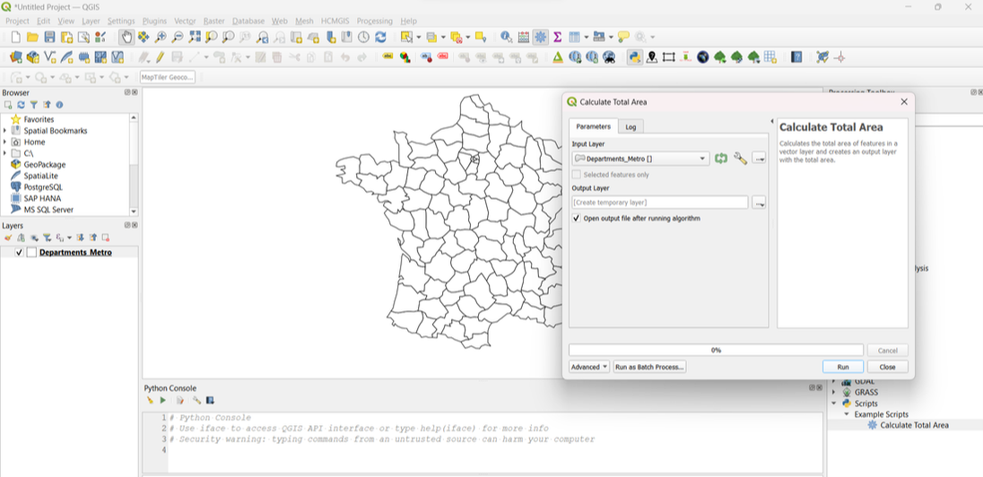
The result will be a new layer with the total area of each feature in the input layer.
Understanding this script is a great step towards harnessing QGIS's scripting capabilities. You can use this knowledge to automate various GIS tasks. Experiment with it, modify it to suit your needs, and explore other QGIS scripts to expand your GIS skills.
 RSS Feed