jps services
  • Home Page
  • GIS Training Courses
    • QGIS Training Courses
    • ArcGIS Training Courses
    • MapInfo Pro Training Courses >
      • MapBasic Training Course
  • About
  • Blog

Standard methods of feature classification  

28/2/2014

0 Comments

 
Desktop GIS software such as ArcGIS, MapInfo and QGIS offer a number of classification methods. The most commonly featured are Natural Breaks (Jenks), Equal Interval, Quantile, Standard Deviation and Manual.
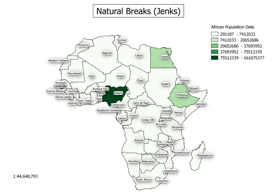
Natural Breaks was developed by George Jenks. This method uses clusters and gaps in the data to create classes.
Natural Breaks (Jenks)
Equal Interval, as it name indicates, creates classes which are of equal value ranges. For example if the value is between 1 and 100 and the number of classes is five, this method creates classes from 1-20, 21-40, 41-60, 61-80 and 81-100.
Equal Interval Example
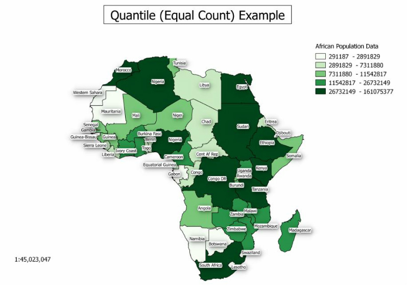
Quantile will create an equal number of features for each class in this method. For instance if you have a 100 features and four classes then each class will contain 25 features.


Quantile (Equal Count) Example
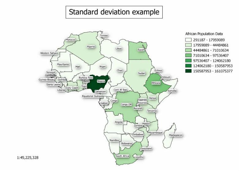
Standard deviation will create classes based on a specific number of standard deviations from a mean value.
Standard deviation example
Finally if you decide to use a manual method you set you own class breaks according to your requirements.

If you would like to further explore how GIS could help your organisation jps services offers one and two day training courses in QGIS, ArcGIS and MapInfo.


0 Comments

Your comment will be posted after it is approved.


Leave a Reply.

    Author

    Joe Short BSc has been involved with various mapping solutions for over twenty years.  If you are considering implementing a GIS  or have ArcGIS Pro, MapInfo Pro or QGIS training requirements, jps services would be happy to be of assistance to your organisation. 

    Archives

    April 2020
    March 2020
    October 2019
    September 2019
    August 2019
    July 2019
    March 2019
    November 2018
    October 2018
    August 2018
    July 2018
    November 2017
    October 2017
    September 2017
    July 2017
    February 2017
    January 2017
    December 2016
    November 2016
    October 2016
    May 2016
    February 2016
    September 2015
    August 2015
    April 2015
    February 2015
    November 2014
    October 2014
    July 2014
    June 2014
    May 2014
    March 2014
    February 2014
    December 2013
    November 2013
    October 2013
    September 2013
    August 2013
    June 2013
    May 2013
    April 2013
    February 2013
    December 2012
    October 2012
    September 2012
    August 2012
    July 2012

    Categories

    All
    Arc Gis
    Arcview
    Autodesk
    Cad
    Gis Training
    Local Government
    Mapbasic
    Mapinfo
    Quantum Gis
    Relational Databases
    Saga Gis

    RSS Feed