In the dynamic landscape of Geographic Information Systems (GIS), where data is at the heart of informed decisions and spatial insights, mastering data management techniques is paramount. Enter arrays and associative arrays—powerful tools in the PHP toolkit that empower GIS enthusiasts to efficiently organize, manipulate, and visualize geospatial information. In this blog, we'll explore how arrays and associative arrays play a crucial role in GIS applications, enhancing data handling and paving the way for seamless spatial exploration.
Arrays: Organizing Spatial Information
Arrays are like digital containers that hold multiple values. In the GIS realm, where datasets can be vast and complex, arrays serve as invaluable assets. Imagine a scenario where you need to store the names of cities for a map visualization. An array can efficiently manage this data:
Arrays: Organizing Spatial Information
Arrays are like digital containers that hold multiple values. In the GIS realm, where datasets can be vast and complex, arrays serve as invaluable assets. Imagine a scenario where you need to store the names of cities for a map visualization. An array can efficiently manage this data:
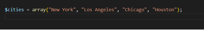
Here, the `$cities` array holds the names of cities, offering a structured and organized approach to data management.
Associative arrays take array functionality to the next level by allowing you to associate values (attributes) with specific keys (identifiers). In a GIS environment, where attributes like population, elevation, and area are essential, associative arrays shine. Let's consider a scenario where you're working with geographic features and their attributes:
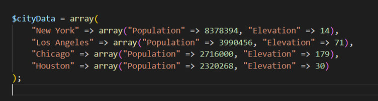
In this example, the `$cityData` associative array pairs city names with arrays containing population and elevation data. This approach allows for intuitive retrieval of attributes based on the city name.
Enhancing GIS Workflows
Arrays and associative arrays seamlessly integrate with common GIS workflows:
1. Data Storage: Arrays provide structured storage for geographic data, making it easier to manage and manipulate.
2. Spatial Queries: Associative arrays enable quick attribute retrieval for spatial queries and analyses.
3. Visualization: Arrays facilitate efficient data visualization by ensuring organized and accessible attribute information.
4. Dynamic Content: Arrays can dynamically populate maps with features, labels, and attribute-driven details.
Fostering Collaboration and Efficiency
In collaborative GIS projects, arrays are invaluable. Team members can contribute by creating and populating arrays with specific geographic data and attributes. This division of labour streamlines teamwork and ensures that the dataset remains coherent.
Conclusion: Empowering Geospatial Exploration
Arrays and associative arrays are pivotal instruments in the GIS toolkit, aiding in the organization, retrieval, and visualization of geospatial data. Whether you're managing lists of coordinates, populating maps with feature data, or associating attributes with geographic entities, arrays offer a structured approach to data handling. As a GIS enthusiast diving into PHP, remember that harnessing the potential of arrays and associative arrays is akin to creating an organized map for your code, enabling you to navigate the world of geospatial data with precision, efficiency, and enhanced insights.
Arrays and associative arrays seamlessly integrate with common GIS workflows:
1. Data Storage: Arrays provide structured storage for geographic data, making it easier to manage and manipulate.
2. Spatial Queries: Associative arrays enable quick attribute retrieval for spatial queries and analyses.
3. Visualization: Arrays facilitate efficient data visualization by ensuring organized and accessible attribute information.
4. Dynamic Content: Arrays can dynamically populate maps with features, labels, and attribute-driven details.
Fostering Collaboration and Efficiency
In collaborative GIS projects, arrays are invaluable. Team members can contribute by creating and populating arrays with specific geographic data and attributes. This division of labour streamlines teamwork and ensures that the dataset remains coherent.
Conclusion: Empowering Geospatial Exploration
Arrays and associative arrays are pivotal instruments in the GIS toolkit, aiding in the organization, retrieval, and visualization of geospatial data. Whether you're managing lists of coordinates, populating maps with feature data, or associating attributes with geographic entities, arrays offer a structured approach to data handling. As a GIS enthusiast diving into PHP, remember that harnessing the potential of arrays and associative arrays is akin to creating an organized map for your code, enabling you to navigate the world of geospatial data with precision, efficiency, and enhanced insights.
 RSS Feed