Geographic Information Systems (GIS) enthusiasts are continually exploring ways to enhance the functionality of their favourite GIS software, QGIS. While QGIS itself is a powerful tool, its extensibility through plugins allows users to customise it to their specific needs. In this blog post, we'll dive into the world of QGIS plugins and explore a unique integration—linking QGIS with PHP. As a GIS user, you'll gain insights into QGIS plugin development and learn how to create a simple QGIS plugin that interacts with a PHP web application.
The Power of QGIS Plugins
QGIS plugins are small software add-ons that extend the capabilities of QGIS. Whether you're looking to streamline workflows, access additional data sources, or perform complex spatial analyses, there's likely a QGIS plugin that can help. These plugins are developed by the QGIS community and third-party developers, making it possible to tailor QGIS to your specific needs.
Getting Started with QGIS Plugin Development
Before we look at PHP integration, let's cover the basics of QGIS plugin development:
1. Development Environment Setup
To get started with QGIS plugin development, you'll need a development environment. Most QGIS plugins are written in Python, so having a basic understanding of Python is essential. Install Python, QGIS, and Qt Designer (a visual tool for designing user interfaces) to set up your development environment.
2. Plugin Builder
QGIS offers a handy Plugin Builder tool that simplifies the creation of new plugins. This tool generates a basic plugin template, including the necessary files and folder structure. It's an excellent starting point, especially for beginners, as it takes care of some of the initial setup complexities.
The Power of QGIS Plugins
QGIS plugins are small software add-ons that extend the capabilities of QGIS. Whether you're looking to streamline workflows, access additional data sources, or perform complex spatial analyses, there's likely a QGIS plugin that can help. These plugins are developed by the QGIS community and third-party developers, making it possible to tailor QGIS to your specific needs.
Getting Started with QGIS Plugin Development
Before we look at PHP integration, let's cover the basics of QGIS plugin development:
1. Development Environment Setup
To get started with QGIS plugin development, you'll need a development environment. Most QGIS plugins are written in Python, so having a basic understanding of Python is essential. Install Python, QGIS, and Qt Designer (a visual tool for designing user interfaces) to set up your development environment.
2. Plugin Builder
QGIS offers a handy Plugin Builder tool that simplifies the creation of new plugins. This tool generates a basic plugin template, including the necessary files and folder structure. It's an excellent starting point, especially for beginners, as it takes care of some of the initial setup complexities.
3. Plugin Development
Once your development environment is set up, you can start coding your QGIS plugin. QGIS plugins typically consist of a combination of Python scripts, XML files for defining user interfaces, and resources like icons or images.
4. Testing and Debugging
QGIS provides a testing framework that allows you to check your plugin's functionality within the QGIS environment. Proper testing and debugging are essential to ensure your plugin works as expected.
5. Documentation and Distribution
Documentation is crucial for users who want to install and use your plugin. Fortunately, QGIS provides tools to create user-friendly documentation. After thoroughly testing and documenting your plugin, you can distribute it to others through the official QGIS Plugin Repository or other platforms.
PHP Integration with QGIS
Now, let's examine the integration of QGIS with PHP. While Python is the primary language for QGIS plugin development, you can indirectly integrate PHP with QGIS through the following steps:
1. Create a QGIS Plugin
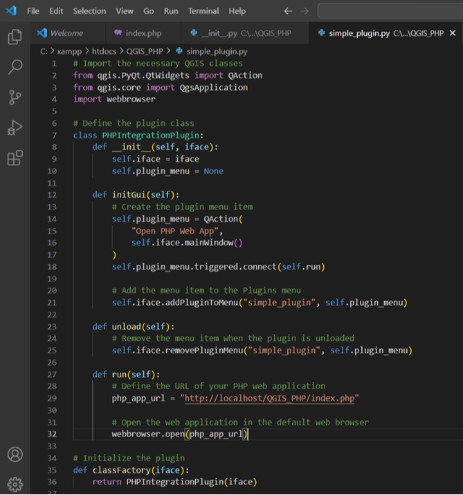
In our example, we'll create a simple QGIS plugin that opens a PHP web application when a menu item is clicked.
Here's the code for the QGIS plugin:
Once your development environment is set up, you can start coding your QGIS plugin. QGIS plugins typically consist of a combination of Python scripts, XML files for defining user interfaces, and resources like icons or images.
4. Testing and Debugging
QGIS provides a testing framework that allows you to check your plugin's functionality within the QGIS environment. Proper testing and debugging are essential to ensure your plugin works as expected.
5. Documentation and Distribution
Documentation is crucial for users who want to install and use your plugin. Fortunately, QGIS provides tools to create user-friendly documentation. After thoroughly testing and documenting your plugin, you can distribute it to others through the official QGIS Plugin Repository or other platforms.
PHP Integration with QGIS
Now, let's examine the integration of QGIS with PHP. While Python is the primary language for QGIS plugin development, you can indirectly integrate PHP with QGIS through the following steps:
1. Create a QGIS Plugin
In our example, we'll create a simple QGIS plugin that opens a PHP web application when a menu item is clicked.
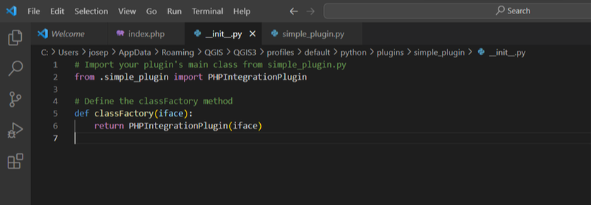
Here's the code for the QGIS plugin:
2. Create a PHP Web Application
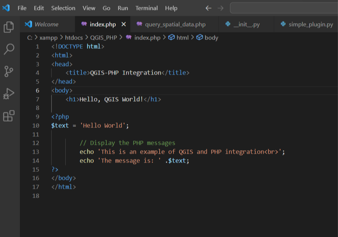
Next, develop a simple PHP web application that serves as the integration point between QGIS and PHP. Your PHP application can offer various functionalities, such as displaying maps, running spatial queries, or visualizing GIS data. For simplicity, we'll create an example that displays a "Hello, QGIS World!" message.
Next, develop a simple PHP web application that serves as the integration point between QGIS and PHP. Your PHP application can offer various functionalities, such as displaying maps, running spatial queries, or visualizing GIS data. For simplicity, we'll create an example that displays a "Hello, QGIS World!" message.
3. Deploy Your PHP Application
Host your PHP web application on a web server or use a local web server like XAMPP or WAMP for development. Ensure that your PHP application is accessible via a URL.
4. Install and Use the QGIS Plugin
Follow the steps below to install and use the QGIS plugin:
- Save the QGIS plugin code as a `.py` file, such as simple_plugin.py.
- Copy the file to the QGIS plugins directory. On most systems, this directory is located at:
- Go to the "Plugins" menu in QGIS, and you should see "simple_plugin" as an option.
- Click "simple_plugin," and it will open the PHP web application in your default web browser.
Host your PHP web application on a web server or use a local web server like XAMPP or WAMP for development. Ensure that your PHP application is accessible via a URL.
4. Install and Use the QGIS Plugin
Follow the steps below to install and use the QGIS plugin:
- Save the QGIS plugin code as a `.py` file, such as simple_plugin.py.
- Copy the file to the QGIS plugins directory. On most systems, this directory is located at:
- Linux: ~/.local/share/QGIS/QGIS3/profiles/default/python/plugins
- Windows: C:\Users\YourUsername\AppData\Roaming\QGIS\QGIS3\profiles\default\python\plugins
- Go to the "Plugins" menu in QGIS, and you should see "simple_plugin" as an option.
- Click "simple_plugin," and it will open the PHP web application in your default web browser.
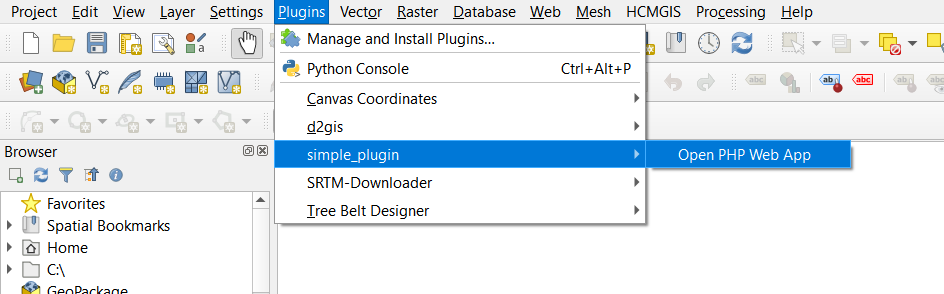
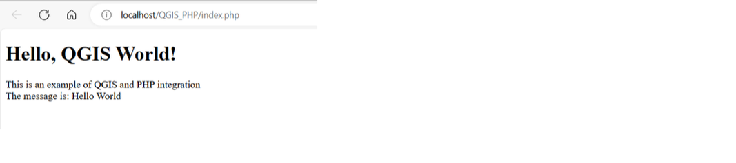
When you click on the simple_plugin it will open the default browser and display a message as in the example below.
In this blog post, we explored QGIS plugin development and created a simple QGIS plugin that integrates with a PHP web application. While QGIS primarily relies on Python for plugin development, the indirect integration with PHP via QGIS plugins and web applications opens up exciting possibilities for extending QGIS's functionality. Whether you're building web-based GIS applications or simply customizing your QGIS experience, this integration can help you achieve your geospatial goals.
 RSS Feed