What Are Functions and Why Do They Matter?
Functions in PHP act as modular units of code that encapsulate a specific set of actions. Just like GIS tools help dissect complex geospatial processes, functions simplify complex programming tasks. This modularity enhances code readability, reusability, and maintainability—essential attributes when dealing with intricate GIS data and operations.
Solving GIS Challenges with Custom Functions
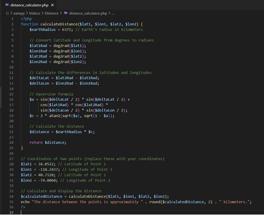
Creating custom functions tailored to GIS needs unlocks a realm of possibilities. Imagine you frequently calculate distances between geographic points. Instead of writing the same code every time, you can create a function to handle this task:
In the above code:
The `calculateDistance()` function takes four parameters: the latitude and longitude of the first point, and the latitude and longitude of the second point.
The function uses the Haversine formula to calculate the distance between the two points in kilometers.
The calculated distance is then displayed using the `echo` statement, rounded to two decimal places for a cleaner output.
Reusing Code for Enhanced Efficiency
When working with GIS data, tasks like data validation, coordinate transformations, and spatial queries are recurrent. Functions allow you to write these procedures once and reuse them throughout your application. For example, a function to validate geographic coordinates can ensure data integrity across different parts of your GIS project.
Fostering Collaborative Development
In collaborative GIS projects, functions streamline teamwork. Team members can contribute by creating functions to handle specific aspects of the application. This division of labour improves efficiency, as team members can focus on their specialized tasks while relying on others' functions.
Optimising Web Applications
Web-based GIS applications thrive on dynamic content and interactivity. Functions play a pivotal role here. For instance, a function that generates dynamic map markers based on attribute values can enhance data visualization and user engagement. A function can also facilitate dynamic SQL queries to retrieve relevant spatial data for display.
Maximizing Code Readability and Maintainability
GIS applications often involve intricate spatial algorithms and data processing. Functions provide a way to compartmentalize these complexities, leading to more readable code. If you encounter a bug or need to make changes, you can focus on the relevant function without disrupting the entire application.
Conclusion: Empowering GIS Applications with Functions
In the dynamic world of Geographic Information Systems, where data-driven decisions and spatial insights drive progress, PHP functions offer a gateway to efficient and effective coding. By creating custom functions tailored to GIS tasks, you elevate your application's efficiency, reusability, and collaborative potential. Whether you're calculating distances, transforming coordinates, or visualizing geospatial data, functions provide the building blocks to elevate your GIS application from concept to reality. As a GIS enthusiast venturing into PHP, remember that harnessing the power of functions is a step toward crafting dynamic, interactive, and impactful geospatial web experiences.

 RSS Feed